
Dividing land into saleable plots starts with jurisdiction, title and surveyed site conditions—not with drawing rectangles on a map. By the end, you will know which records to assemble, what a compliant layout must show, how roads and drainage affect plot yield, and which approvals must be checked before marketing or construction.
Key takeaways
- Confirm the approving authority before preparing plot boundaries.
- Use a measured survey with title documents and access details.
- Deduct roads, open space, drainage and utilities before pricing saleable plots.
- Obtain land-use, layout and development permissions before marketing plots.
Start with jurisdiction, title and a measured site survey
Before drawing a single plot boundary, confirm the parcel’s planning jurisdiction, lawful ownership and measured ground position. A subdivision plotting layout service in Nagpur must identify whether approval falls to Nagpur Municipal Corporation, Nagpur Metropolitan Region Development Authority or another local planning authority, then apply the relevant Development Plan, Regional Plan and Maharashtra UDCPR provisions.
Assemble and cross-check:
- Registered sale deed, 7/12 extract or property card, mutation entries and encumbrance details.
- Village or city survey map, sanctioned road network, existing rights of way and the proposed site boundary.
- Zone certificate, land-use status and any agricultural-to-non-agricultural or deemed-conversion compliance.
- A total-station or GPS survey showing north, levels, adjoining roads, drains, watercourses, structures, boundary markers and access points.
- Development-plan reservations, road-widening lines, flood-prone ground and utility corridors.
| Drawing or record | What it establishes | What it cannot replace |
|---|---|---|
| Land plotting plan | Proposed plot divisions and areas | Approval or title verification |
| Subdivision layout | Roads, open spaces, amenities, drainage and plot schedule | The authority’s sanction |
| Building-site plan | Setbacks and construction position for one plot | A full subdivision design |
| Development Plan | Public reservations and planned infrastructure | A measured boundary survey |
Do not advertise agricultural land as ready-to-build plots before land-use and development permissions are checked. For a RERA-covered project, keep the sanctioned layout, title, encumbrances, amenities and completion promises consistent with sales material, and do not collect more than 10% of the plot price before executing the agreement for sale.
Know what the layout drawing must contain
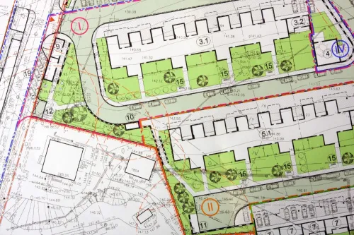
A complete plot subdivision layout in Nagpur should let you match every proposed plot to the surveyed land, access, services, and approval conditions—not merely show attractive rectangles. It should contain:
- Surveyed site boundary, adjoining properties, north direction, levels, existing structures, trees, watercourses, and access road
- Internal road alignments, widths, turning areas, road-widening lines, and connections to the sanctioned road network
- Plot numbers, dimensions, corner points, areas, building lines, and required setbacks
- Open spaces, amenity areas, utility sites, drainage lines, rainwater routes, and service corridors
- A schedule of total land, roads, open space, utilities, affected reservations, and net plot area
Ask for the survey drawing, title and land-record references, zoning or zone-certificate basis, reservation markings, flood-prone areas, existing rights of way, and the authority’s jurisdiction. The drawing must identify whether each area is saleable, transferable, handed over, or reserved for a stated use.
| Drawing | What it shows | What it does not establish |
|---|---|---|
| Land plotting plan | Proposed plot arrangement, dimensions, and access | Approval or legal saleability |
| Subdivision layout | Coordinated roads, plots, open spaces, utilities, drainage, and area schedule for approval | Permission to construct any building |
| Building-site plan | One plot’s building position, setbacks, parking, and services | Division of the larger parcel |
| Sanctioned development plan | Wider planning reservations, land use, and major roads | The final plot-by-plot subdivision design |
Calculate saleable plots after roads, open space and drainage
Do not divide the advertised gross land area by your preferred plot size. Use the measured site area, then prepare an area statement that separates land proposed for private plots from every area required for access, public use and infrastructure.
- Deduct internal roads, turning areas, road-widening strips and the legal connection to the public road.
- Deduct required open space and amenity land; do not count either as saleable inventory unless the sanctioned layout expressly permits it.
- Deduct utility corridors, transformer space, drainage reservations and land occupied by existing drains or watercourses.
- Exclude irregular corners, setbacks, slopes and leftover strips that cannot meet the approved minimum plot dimensions.
The remaining area is a design pool, not automatically the final saleable area. Divide it into plots only after checking each plot’s frontage, depth, access, dimensions and building potential against the sanctioned layout and applicable Maharashtra UDCPR provisions.
A digital schedule should show every plot number, measured area, road area, open space, amenity area, utility area and balance.
Storm-water design changes the calculation. Set road levels, plot platforms, culverts, recharge measures and the receiving drain together; raising plots without a lawful outfall can push monsoon water onto adjoining land or public roads. In a residential plotting layout in Nagpur, also record who will own, maintain or receive each non-saleable area.
Marketing must use the approved net plot schedule, not the brochure’s gross figure.
Check planning permissions, land use and buyer-facing obligations
Before advertising or accepting bookings, confirm that the parcel may be used and developed for residential plots. Agricultural land cannot become “ready-to-build” merely because a land plotting plan in Nagpur has been drawn.
Check these approvals against the parcel’s planning jurisdiction and the applicable Development Plan or Regional Plan:
- Confirm the competent authority: Nagpur Municipal Corporation, Nagpur Metropolitan Region Development Authority, or another local planning authority.
- Obtain the applicable zone certificate and verify residential use, reservations, road-widening lines, flood restrictions, and access.
- Confirm the required development permission and any non-agricultural permission or deemed-conversion compliance under Maharashtra land-revenue rules.
- Secure the sanctioned subdivision layout, including approved roads, open space, amenity land, drainage and utility arrangements.
- Check whether the project requires MahaRERA registration. A promoter who subdivides land and offers plots for sale cannot replace registration, sanctioned plans or disclosures with a document marked “concept layout”.
| Document or approval | What it proves | What it does not prove |
|---|---|---|
| Sanctioned subdivision layout | The approved division, roads and reserved areas | That every plot may support any building |
| Building permission | A specific building proposal is permitted | That the entire plotted project is approved |
| Concept layout | An early design proposal | Permission to advertise, sell or construct |
For a RERA-covered project, match the sale material with the sanctioned layout, title, encumbrances, amenities and completion obligations. Do not collect more than 10% of the plot price before executing the agreement for sale. Open space, roads and utility land are not saleable inventory unless the approval expressly permits that treatment.
Choose a design package that can support approval and delivery
Ask the plot development planning in Nagpur service for an approval-ready package, not just a coloured layout. It should identify the competent authority—such as Nagpur Municipal Corporation, Nagpur Metropolitan Region Development Authority, or another local planning authority—and match the applicable Development Plan or Regional Plan.
Request these deliverables:
- Measured topographic survey with boundary and corner coordinates, contours, spot levels, trees, structures, utilities, road levels and drainage observations.
- Dimensioned subdivision drawing showing plot numbers, areas, access, internal roads, setbacks, open space, amenity and utility areas.
- Digital area statement separating gross land, roads, open space, infrastructure and net saleable plots.
- Submission drawings, ownership documents, zoning evidence and a list of approval conditions, revisions and responsibilities.
Use this comparison before appointing a service:
| Package | Deliverable | Start trigger |
|---|---|---|
| Approval layout | Sanction-submission drawings and area schedule | Survey, title and jurisdiction confirmed |
| Architectural design | Plot-specific building concept, setbacks, floor-space index, height and parking checks | Permitted land use and plot controls confirmed |
| Construction package | Detailed drawings, specifications, quantities and execution coordination | Layout sanctioned and separate building permission available |
Arch'N' Angles Architect's can be assessed on whether it separates these stages rather than promising construction from an unapproved plotting plan. A residential layout approval does not authorise a commercial block, rental workspace or modular office; confirm zoning, fire, utilities and building permission before architectural or construction support begins.
Related product
Residential & Commercial Sector Subdivision Plotting Of Layout Subdivision Plotting Of Layout |
Frequently asked questions
Which authority approves a subdivision plotting layout in Nagpur?
Approval depends on the parcel’s location and planning jurisdiction. Check whether Nagpur Municipal Corporation, Nagpur Metropolitan Region Development Authority or another local planning authority has control, then apply the relevant Development Plan, Regional Plan and Maharashtra UDCPR provisions.
What must a plot subdivision layout drawing contain?
The drawing should show the surveyed boundary, dimensions, plot numbers and areas, access roads, road widths, open space, drainage, utilities, north direction, adjoining roads and other site constraints needed for review and construction.
How do you calculate saleable plots in a residential plotting layout?
Start with the surveyed parcel area, then deduct land required for roads, open space, drainage, utilities and other approved reservations. Divide the remaining developable area into plots that meet applicable access, frontage and dimensional requirements.
What should you verify before marketing plotted land in Nagpur?
Verify ownership, encumbrances, land use, the approving authority, layout permission, development obligations, road and drainage provisions, utility access and the documents buyers will receive.
Keywords